
By: Isuru Parakrama
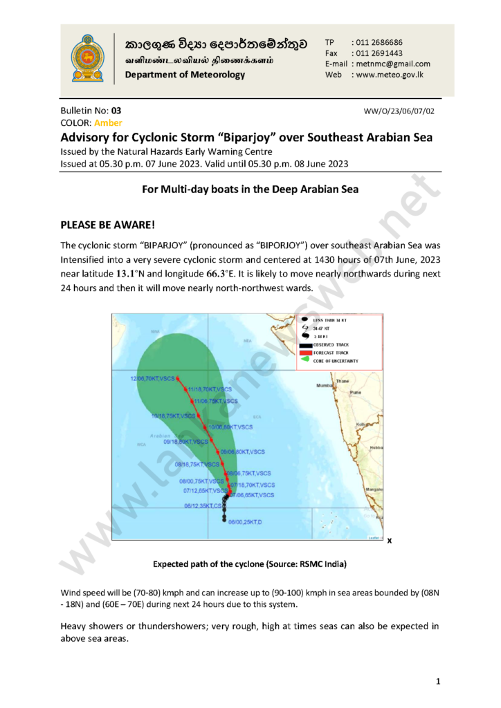
Colombo (LNW): The cyclonic storm “BIPARJOY” over southeast Arabian Sea was intensified into a very severe cyclonic storm and centred at 1430 hours of June 7 near latitude 13.1 °N and longitude 66.3 °E. It is likely to move nearly northwards during next 24 hours, later to move nearly north-northwest wards, warned the Natural Hazards Early Warning Centre of the Department of Meteorology.
Meanwhile, showers or thundershowers will occur at times in Western and Sabaragamuwa provinces and in Galle and Matara districts and fairly heavy showers above 75mm are likely at some places in the Sabaragamuwa Province and in Galle, Matara and Kalutara districts, said the Department of Meteorology in its daily weather forecast today (08).
Several spells of showers will occur in North-Western province and in Jaffna district.
Showers or thundershowers will occur at a few places in Uva and Central provinces and in Ampara and Batticaloa districts during the evening or night.
Strong winds about (40-45) kmph can be expected at times in Northern and North-Central provinces and in Hambantota, Puttalam and Trincomalee districts.
General public is kindly requested to take adequate precautions to minimise damages caused by temporary localised strong winds and lightning during thundershowers.
Marine weather:
Condition of Rain:
Showers or thundershowers will occur at times in the sea areas off the coast extending from Puttalam to Matara via Colombo and Galle.
Winds:
Winds will be south-westerly over sea area around the island and speed will be (25-35) kmph.
Wind speed may increase up to (50-60) kmph at times in the sea areasoff the coast extending from Puttalam to Trincomalee via Mannar and Kankasanthurai and from Hambantota to Pottuvil. Wind speed may increase up to (40-50) kmph at times in the sea areasoff the coast extending from Puttalam to Hambantota via Colombo and Galle.
State of Sea:
The sea areasoff the coast extending from Puttalam to Trincomalee via Mannar and Kankasanthurai and from Hambantota to Pottuvil will be rough at times. The sea areasoff the coast extending from Puttalam to Hambantota via Colombo and Galle will be fairly rough at times.
There is a possibility to increase swell waves (about 2.0 – 2.5 m) in the sea areas off the coast extending from Puttalam to Pottuvil via Colombo, Galle and Hambantota.
Temporarily strong gusty winds and very rough seas can be expected during thundershowers.