
By: Isuru Parakrama
May 26, Colombo (LNW): Due to the South West Monsoon condition, the prevailing showery and windy conditions are expected to continue, the Department of Meteorology said in its daily weather forecast today (26).
Showers or thundershowers will occur at times in Western, Sabaragamuwa, Central, North-western and Southern provinces.
Heavy showers above 100 mm are likely at some places in Sabaragamuwa province and in Nuwara-Eliya district.
Fairly heavy showers about 75 mm are likely at some places in Western and North-western provinces and in Kandy, Galle and Matara districts.
Several spells of showers will occur in Northern and North-central provinces.
A few showers may occur in Eastern province.
Strong winds of about (50-60) kmph can be expected at times over Western slopes of the central hills and in Northern, North-central, Western, Southern and North-western provinces and in Trincomalee district.
Fairly strong winds about (30-40) kmph can be expected at times elsewhere of the island.
Marine Weather:
| Condition of Rain: |
| Showers or thundershowers will occur at times in the sea areas extending from Mannar to Hambantota via Colombo and Galle. Showers or thundershowers may occur at few places in the other sea areas around the island. |
| Winds: |
| Winds will be south-westerly in the sea areas around the island. Wind speed will be (40-50) kmph and wind speed may increase up to (60-70) kmph at times in the sea areas extending from Kankasanturai to Pottuvil via Mannar, Colombo, Galle and Hambantota. Wind speed will be (30-40) kmph and can be increased up to (50-60) kmph at times in the other sea areas around the island. |
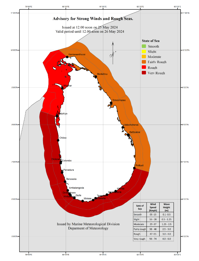
| State of Sea: |
| The sea areas extending from Kankasanturai to Pottuvil via Mannar, Colombo, Galle and Hambantota will be very rough at times and Naval and fishing communities are advised not to venture into these sea areas, until further notice. The other sea areas around the island will be rough at times, therefore, naval and fishing communities in this sea area are requested to be vigilant in this regard. The swell waves (about 2.5–3.0 m) height (this is not for land area) may increase in the sea areas off the coast extending from Kankasanturai to Pottuvil via Mannar, Kalpitiya, Colombo, Galle, and Hambantota. Temporarily strong gusty winds and very rough seas can be expected during thundershowers. |
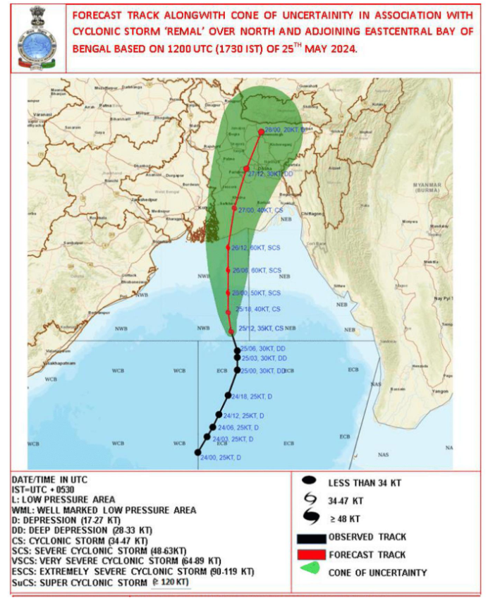
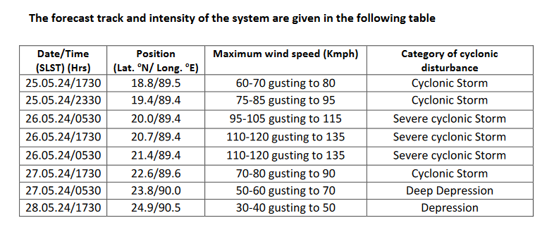
The Deep Depression over East central Bay of Bengal has intensified into a Cyclonic storm and located near 18.8°N and 89.5°E at 05.30 p.m. of 25th May. The Cyclonic storm has named “Remal” (PRONOUNCED AS “Re-Mal”). It is very likely to move northwards and intensify into a severe cyclonic storm by 26th May morning. Thereafter, it would move northwards and cross Bangladesh and adjoining west Bengal coasts by 26th May midnight.
Very strong winds (60-70) kmph, accompanied with heavy rainfalls and very rough seas are likely over the sea areas around the country and over the South-eastern Arabian Sea areas and Bay of Bengal.
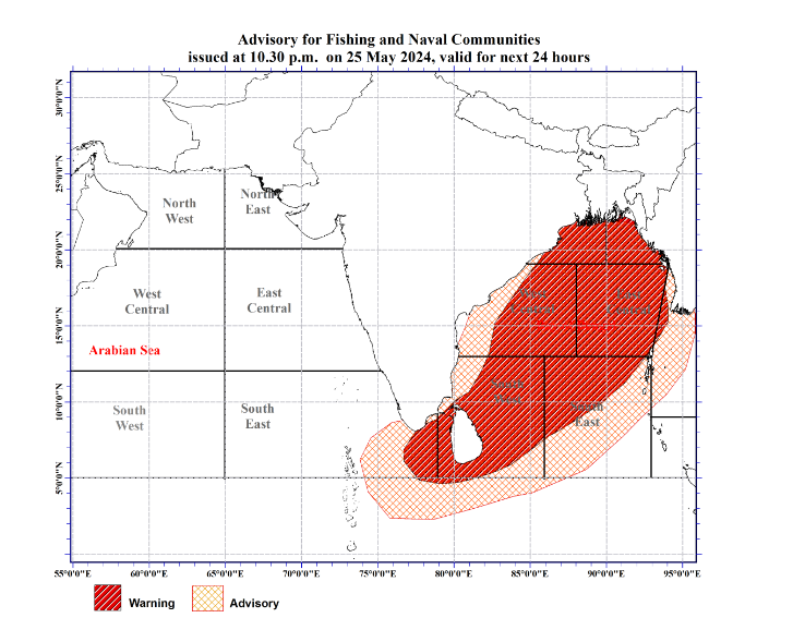
Naval and fishing communities are advised not to venture into the sea areas marked by RED colour on the map above until further notice.
Expected path of the cyclone (Source: RSMC India)
Actions Required:
- Those who are out at aforementioned sea regions are advised to return to coasts or moved safer areas immediately.
- Fishing and naval community are requested to be attentive to future forecasts issued by the Department of Meteorology in this regard.