
By: Isuru Parakrama
May 28, Colombo (LNW): The prevailing showery and windy conditions are expected to continue further, due to the active South West Monsoonal condition.
Showers or thundershowers will occur at times in Western, Sabaragamuwa, Central, North-western and Southern provinces.
Heavy showers above 100 mm are likely at some places in Western and Sabaragamuwa province and in Nuwara-Eliya district.
Showers or thundershowers will occur at several places in Uva province and in Ampara and Batticaloa districts in the evening or night.
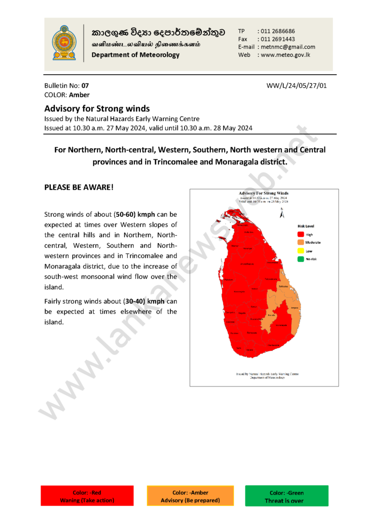
Strong winds of about (50-60) kmph can be expected at times over Western slopes of the central hills and in Northern, North-central, Western, Southern and North-western provinces and in Trincomalee and Monaragala districts.
Marine Weather:
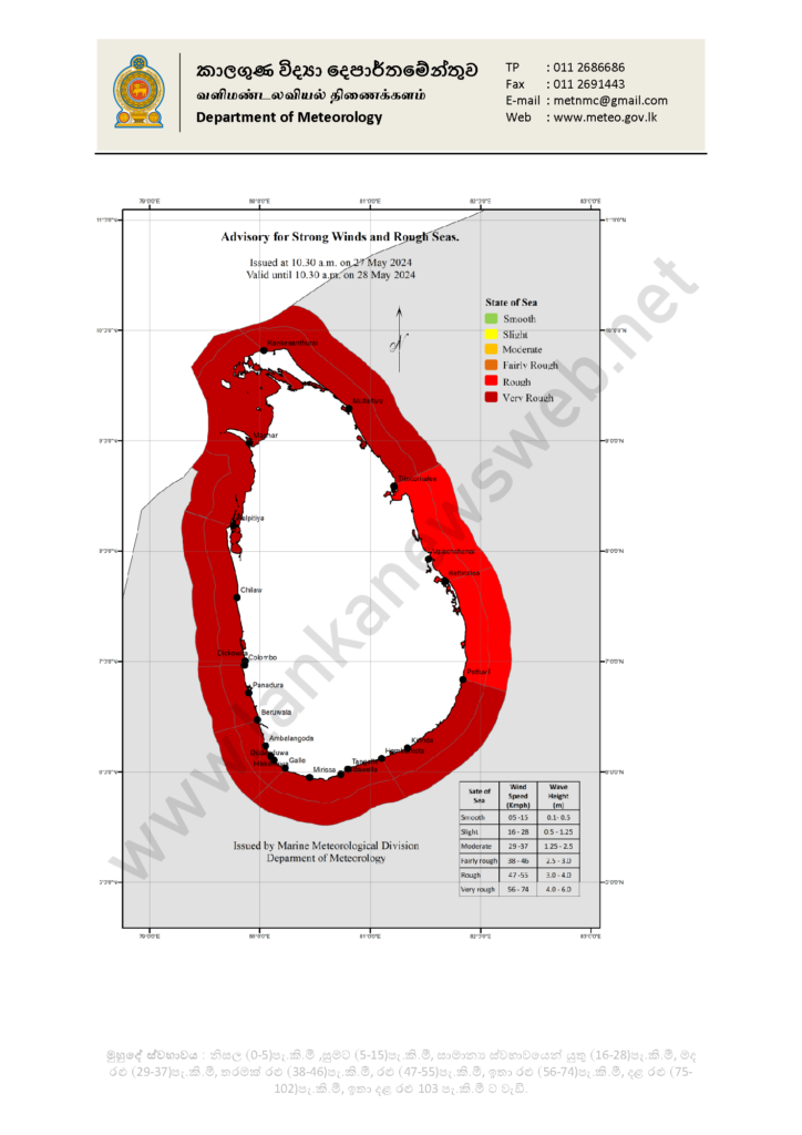
| The sea areas around the island will be very rough due to the active south-west monsoonal condition. Naval and fishing communities are advised not to venture into the sea areas around the island, until further notice. |
| Condition of Rain: |
| Showers or thundershowers will occur at times in the sea areas extending from Puttalam to Hambantota via Colombo and Galle. |
| Winds: |
| Winds will be south-westerly in the sea areas around the island. Wind speed will be (40-50) kmph and wind speed may increase up to (60-70) kmph at times. |
| State of Sea: |
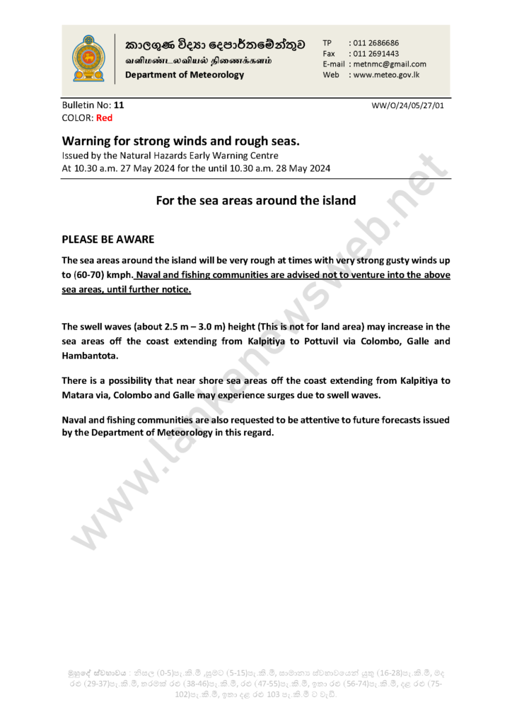
| The sea areas around the island will be very rough at times The swell waves (about 2.5–3.0 m) height (this is not for land area) may increase in the sea areas off the coast extending from Kalpitiya to Pottuvil via Colombo, Galle, and Hambantota. Temporarily strong gusty winds and very rough seas can be expected during thundershowers. |
There is a possibility that near shore sea areas off the coast extending from Kalpitiya to Matara via, Colombo and Galle may experience surges due to swell waves.
Naval and fishing communities are also requested to be attentive to future forecasts issued by the Department in this regard.
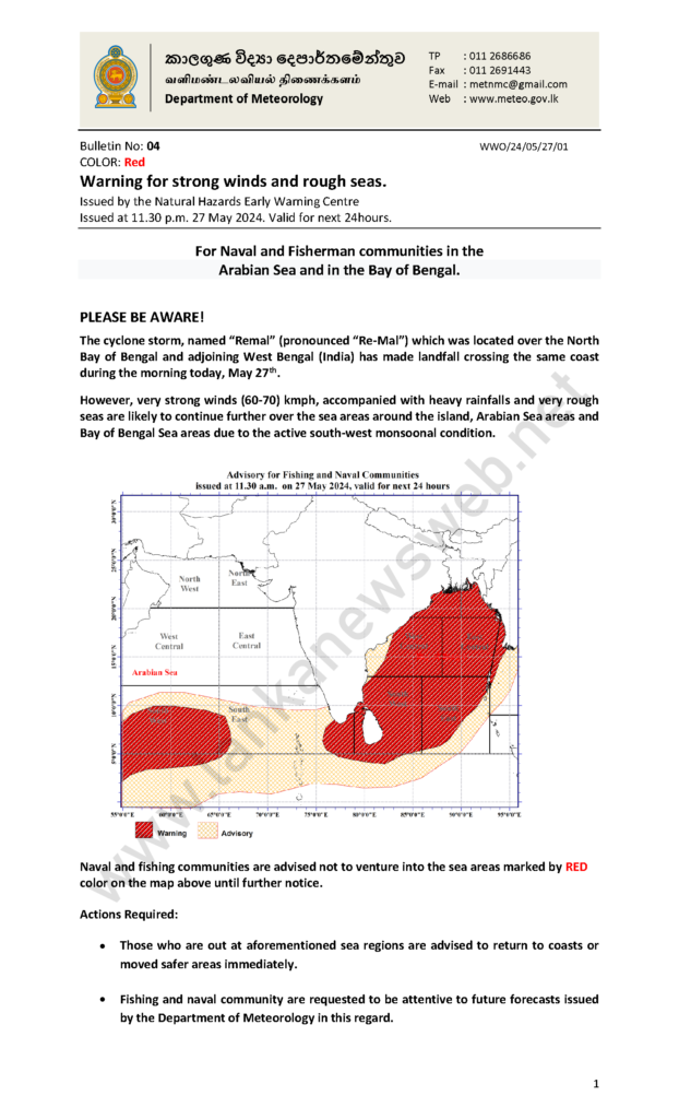
Meanwhile, the cyclonic storm known as “Remal” located over the North Bay of Bengal and adjoining West Bengal (India) has made landfall crossing the same coast during the morning yesterday (27).
However, very strong winds (60-70) kmph, accompanied with heavy rainfalls and very rough seas are likely to continue further over the sea areas around the island, Arabian Sea areas and Bay of Bengal Sea areas due to the active south-west monsoonal condition.
Naval and fishing communities are advised not to venture into the sea areas marked by RED colour on the map above until further notice.
Actions Required:
- Those who are out at aforementioned sea regions are advised to return to coasts or moved safer areas immediately.
- Fishing and naval community are requested to be attentive to future forecasts issued by the Department of Meteorology in this regard.
Strong winds of about (50-60) kmph can be expected at times over Western slopes of the central hills and in Northern, North-central, Western, Southern and North-western provinces and in Trincomalee and Monaragala district, due to the increase of south-west monsoonal wind flow over the island.
Fairly strong winds about (30-40) kmph can be expected at times elsewhere of the island.